
Maps
There are a number of online maps that provide a fascinating look into the history of the Quabbin.
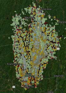 Before the Quabbin was created, Massachusetts sent teams of surveyors and photographers out to document all of the properties that would be taken by the state. This information has been compiled into archives and GIS maps. By zooming in and clicking on a property you can learn more about who lived there.
Click here to access this map.
The process of getting additional information from this map is a little bit complicated, so click here for instructions on how to access this data.
You can also download the app “ArcGIS Field Maps” from the Apple Store or Google Play to use when you are hiking in the Quabbin. This is great for when you find a cellar hole and are curious whose house it was!
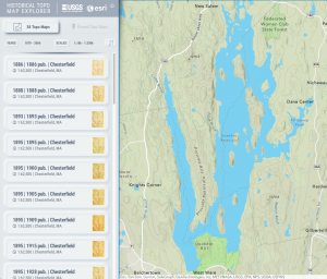 This site allows the user to overlay maps of different years over the existing terrain. You can then vary the opacity of the overlaid map to see what it looked like then and now.